|
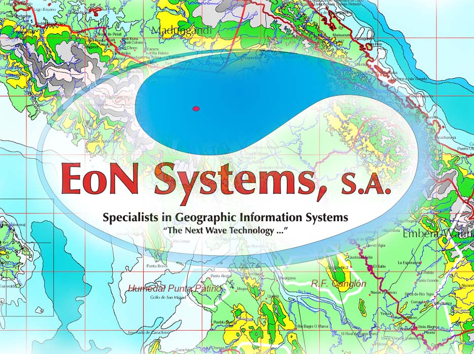
EoN Systems, S.A. |
"Next Wave Technology" |
|||||||||||||||||||||||||||||||||||||||||||||||||||||||||||||||||||||||||
|
|
|||||||||||||||||||||||||||||||||||||||||||||||||||||||||||||||||||||||||||
Specialists in Information SystemsEoN Systems, S.A., provides consulting services and products in geographic information systems (GIS), remote sensing, custom software applications and advanced computer technology. EoN is a privately held Panamanian corporation. In addition, EoN has skills in project management, social sciences studies, anthropological research, social impact assessment, demographics, cultural geography and cultural and natural resource management. Our experience covers a wide range of applications in the commercial, government, military and institutional sectors. Our highly trained staff and advanced computer laboratory meet the challenge of projects having the most demanding and rigorous technical requirements. EoN specializes in providing applications, consulting and products in several key areas:
Geographic
Information Systems (GIS)
| |||||||||||||||||||||||||||||||||||||||||||||||||||||||||||||||||||||||||||

| cadastral survey use of high-precision GPS technology to develop digital geodesic networks for integration with GIS systems. Applications include definition of legal boundaries, site survey and parcel layout. | |
| engineering GIS preparation of 3D models, cut-and-fill analysis, volumetric calculation, area, profiles and cross-sections. Applications include earth moving activities such as mining, drilling and blasting, excavation projects, road corridors, quarries and dredging. | |
| automated mapping and facility management (AM-FM) GIS for electric, water and communication utilities. Application involves routing, distribution, allocation, resource management and route and network analysis. | |
| commercial and corporate GIS marketing, competitive, socio-economic, demographic & site-location analysis. | |
| government agency GIS managing agency resources and performing spatial analysis | |
| scientific GIS remote sensing, managing and analyzing spatial data and associated attributes for research. | |
| cultural and natural resource management for NGOs, conservation groups, agricultural organizations and government agencies that manage cultural and natural resources. | |
| military GIS base ops., project management, engineering, battlefield simulation, intelligence and tactical operations. |
We provide complete services for GIS applications:
|
analysis of digital aerial photographs and satellite images, including digitizing of aerial photographs, adjustment and geo-referencing of images and creation of photo-mosaics |
|
|
analysis and classification of raster images, including vegetation and land use classification systems |
|
|
high-resolution large-format scanning and printing |
|
|
data entry and capture, digitizing and conversion of spatial data from paper or images to geo-referenced digital formats, including conversion from one data format to another |
|
|
integration of digital maps and databases with both vector and raster data |
|
|
visual and spatial analysis of data and thematic mapping for presentation and publication |
|
|
GIS-application development for turnkey systems |
|
|
complete training and technical support for GIS, database and remote sensing applications |
We offer comprehensive, one-stop shopping for geographic information systems solutions: needs assessment, creation of a functional prototype, application development, data capture, digital mapping, data-GIS integration and completed GIS delivery, along with comprehensive training and technical support.
Local and Regional GIS Product Sales
![]()
EoN sell a wide range of local, regional, national and international GIS databases and products. We specialize in the creation of vector GIS databases from raster images whether from paper, Mylar, CAD drawings or other raster images. With our advanced digitizing technology we can deliver complex products quickly meeting or exceeding the most demanding technical requirements.
Our extensive line of national GIS databases is based on the following flagship products:
Satellite Imagery High-resolution ortho-photography and satellite imagery.
Aerial Photography - high resolution aerial photography in digital format of the Panama metro area covering from Tocumen to Chorrera. Includes the Pacific terminus of the Panama Canal, Panama city and the main urban area of San Miguelito. This 1:10,000 scale photography has the resolution to prepare 1:2,500 scale map products.
SIG Panama 1:2,500 scale vector GIS database of the Republic of Panama based upon paper sources from the Dept. of Census and Statistics, Controloria . Has all buildings, census blocks, census data, political boundaries, transportation network, bridges and hydrology. Updated with year 2000 data.
SIG Republic 2000 1:250,000 scale vector GIS database of the Republic of Panama. Has towns, transportation network, hydrology, contours, protected area and political boundaries. Derived in part from the 1:250,000 scale paper maps provide by the Instituto Geografico Tommy Guardia.
In addition to the products listed above EoN has an extensive library of GIS databases of environmental, ecological and socio-economic GIS data that combine perfectly with our flagship products. Some specific examples are:
|
Life
Zones or Vegetation Forms of the World by L. R. Holdridge -
Scale 1:2,000,000 and published by the Instituto Geográfico
Nacional Tommy Guardia in 1985. This paper map of the Republic
of Panama has 12 classifications of life zones. EoN converted this
data to a vector digital format to integrate seamlessly with SIG Republic.
|
|
|
Climatological
Map (after Koppen) Scale 1:2,000,000 published by the Instituto
Geográfico Nacional Tommy Guardia in 1985. This paper map of the
Republic of Panama has five climate classification. EoN converted
this data to a vector digital format to integrate seamlessly with SIG
Republic. |
|
|
Geological
Map of the Republic of Panama - Scale: 1:250,000 published by the
Instituto Geográfico Nacional Tommy Guardia in 1985. This database
has fault line and geological formations. EoN converted this data to
a vector digital format to integrate seamlessly with SIG Republic. |
|
|
|
Social
Assessment Cultural and
Natural Resource Management
![]()
EoN provides consulting in social impact assessment and cultural and natural resource management. We have the ability to quickly assemble a sophisticated inter-disciplinary team that combines our project management, information system technology, GIS and cultural and natural resource management skills with regional and local bilingual consultants in biology, forestry, hydrology, geology, ecology, anthropology, archaeology, geography, market research and social analysis to support projects.
Our long history in Panama and the Central American region spans work with Gorgas Memorial Laboratory, CEASPA, National Environmental Authority (ANAM), Panama Canal Authority (ACP), Panamanian Institute of Tourism (IPAT), Ministry of Agricultural Development (MIDA), Ministry of Economy and Finance (MEF), Ministry of Health (MIDA), US Agency for International Development (USAID), Organization of American States (OAS), Smithsonian Tropical Research Institute (STRI), World Bank, Gamboa Rainforest Resort, Social Development Fund (FIS) , Edemet-Edechi, World Conservation Union (IUCN), U.S. Army South (Panama), United States Southern Command (USSOUTHCOM) and Interoceanic Regional Authority (ARI).
Our excellent working knowledge of local and regional resources, networking relationships and experience supports complex initiatives. Our longstanding research, support and consulting activities with national indigenous groups positions us for analyzing complex social and ecological problems that indigenous and campesino populations face.
Our GIS products and databases incorporate many socio-economic and demographic indicators. These variables, when combined with the physical and political geography in digital maps, permit the construction of sophisticated models of cultural tendencies and profiles of socio-economic behavior. EON provides cultural resources management, social science and ecology-related consulting in:
|
background research for social and natural resource impact assessment studies |
|
|
cultural geography and demographic studies |
|
|
identification, assessment and management of cultural resources for pre-historic and historic sites |
|
|
background research for management alternatives evaluation and selection for social development projects |
|
|
training program assessment, design and implementation |
|
|
anthropological and political analysis in Panama and the Latin American region |
|
|
development of questionnaires and statistical analysis of complex data sets |
|
|
support for projects in natural resource management and tropical ecosystem conservation |
|
|
consulting in eco-tourism management, creation of national heritage interpretative products |
|
|
integration of GIS with database systems for natural & cultural resource management projects |
Relational Database Management Systems (RDBMS) & Custom Programming
![]()
Microsoft Access, Visual Basic and Microsoft SQL Server are our database and programming environments. We have strong skills and experience in developing large scale, enterprise-wide, multi-user, secure relational database management applications.
We have created numerous custom systems in dozens of application areas, including inventory, budgeting, emergency response, telecommunications, resource management, personnel, training, critical document control, scientific and epidemiological research, military operations, conservation and natural resource management. Current examples of applications we have designed and programmed are: GIS and Project Management System for Rural Poverty for the Panama Ministry of Agricultural Development (MIDA) and the Forestry Information System (SIF) for the National Environmental Authority (ANAM).
Technology
Transfer, Customized Training
and Technical Support
![]()
EON
excels in all areas of computer training and computer-training curriculum
development. We can customize training for a clients specific needs.
Our computer laboratory offers courses in introductory and advanced GIS such as
ArcView, using and programming relational database management systems with
Microsoft Access and general office productivity applications such as Microsoft
Office. We provide training in both English and Spanish.
Multimedia
Projects and
Advanced Digital Graphics
![]()
EON also manages graphic, sound and video data for multimedia applications. We specialize in the design and creation of multi-media applications that involve digital maps and relational database management systems. Our laboratorys digital scanners, CD ROM writers, video capture hardware, digital sound recording and digital cameras complement graphics software to meet the needs of complex multimedia projects.
Telecommunications,
Networking,
Intranets & the Internet
![]()
We design, implement and support local area networks and Intranets using Microsoft Server. Many of our network applications support database management systems and GIS application that we design, build and install on the local area network, Intranet or Internet server.
All
content on this website -
(c) copyright 2002, EoN Systems, S.A.
All Rights Reserved
unless otherwise noted
for
information concerning this site contact:
info@trail2.com
privacy policy - we do not collect personal information on this website
.
Contact Information:
EoN
Systems, S.A.
info@trail2.com
Web
Site:
www.trail2.com
Download
EoN Corporate
Brochure in .PDF Format
(2 megabytes)
Download
EoN Corporate
Brochure in .PDF Format
(no graphics, 75 kilobytes)
Looking
for the Embera Drua Website
for ecological and heritage tourism?
Looking for the TCR Tourism,
Conservation and Research
Website?
TCR
Strategic Alliance
Tourism-Conservation-Research
A
Report from the Conference on
"Heritage Tourism for the Next Millenium"
And its Symposium on
"The Challenge of Experience-Management:
Linking Quality with Sustainability
Looking
for The
History of the
Las Cruces Trail and
Adjacent Canal Area?
A
Historic Review of the Events and Persons Associated with the Different
Trans-Isthmian Crossings and Routes in Panama
from the Camino Real and Las Cruces Trail, the construction of the Panama
Railroad and the subsequent construction and operation of the Panama Canal and
the Trans-Isthmian Highway
by Susan Harp
www.trail2.com/embera/history.htm
Looking for the Finca Tupisa website?
Looking for the Fundación Darien - a Native American pro-community development organization?
Graphics below may be freely used for educational, personal or other non-commercial use provided that the source is explicitly acknowledged. .
(c) Copyright
2002,
EoN Systems, S.A.
All Rights Reserved
Watch the site for new additional high quality educational graphics in the near future
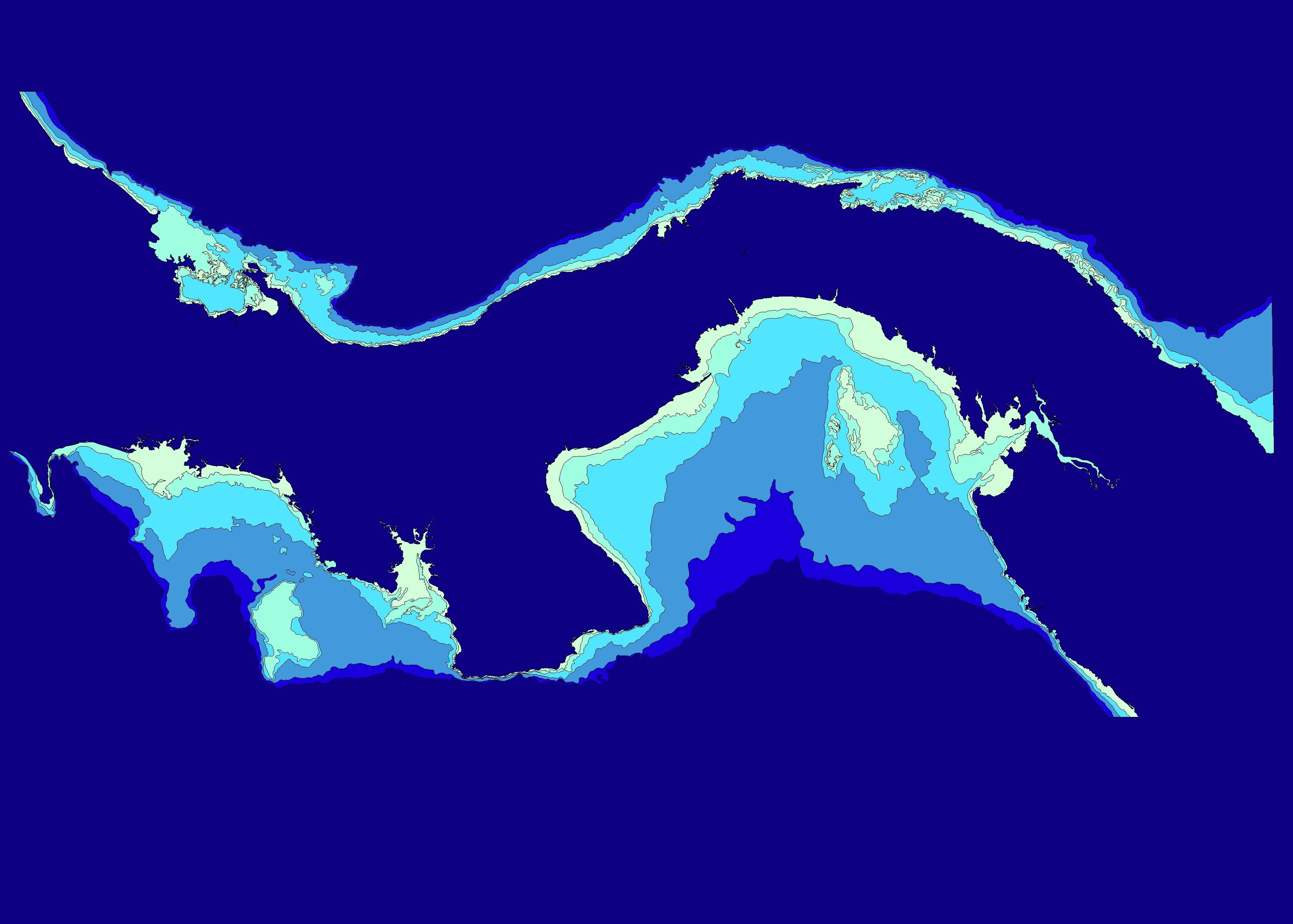
3368x2409 pixels - 389 kb
Outline map and ocean depth contours of the Republic of
Panama. Created from
SIG Republic 2000
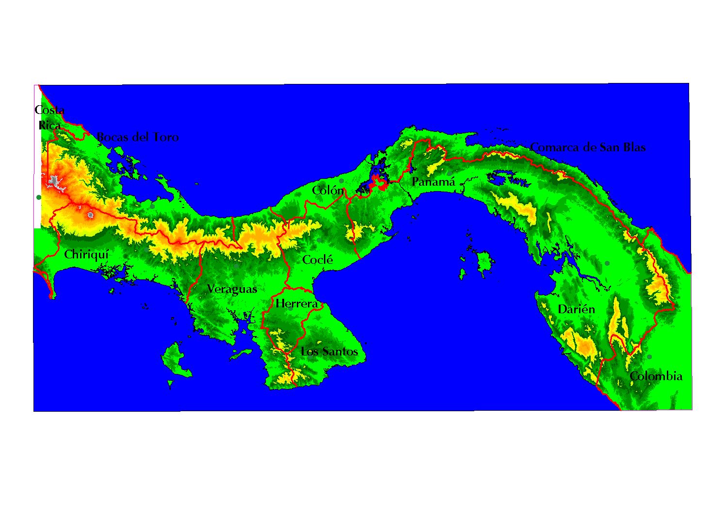
1494x1062 pixels - 200 kb
Terrain map of the Republic of Panama. Has older provincial boundaries. Created from SIG Republic 2000
2479x1756- pixels - 300 kb
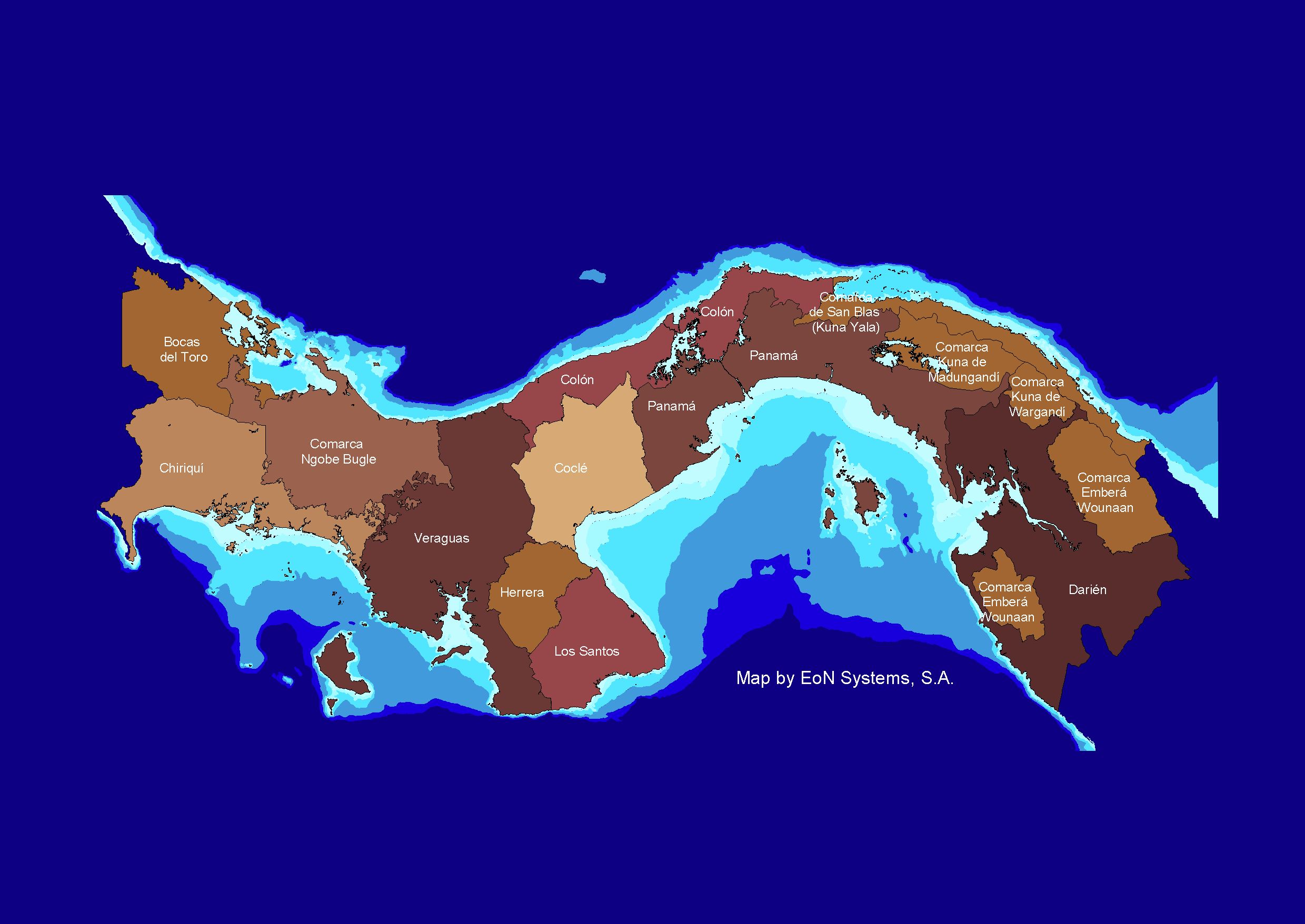
Political Map Provinces and Comarcas with ocean depth
contours of the Republic of Panama. Based upon the latest political
modifications. Great for Powerpoint presentations. Created from
SIG Republic 2000
1903x2486 pixels - 704 kb
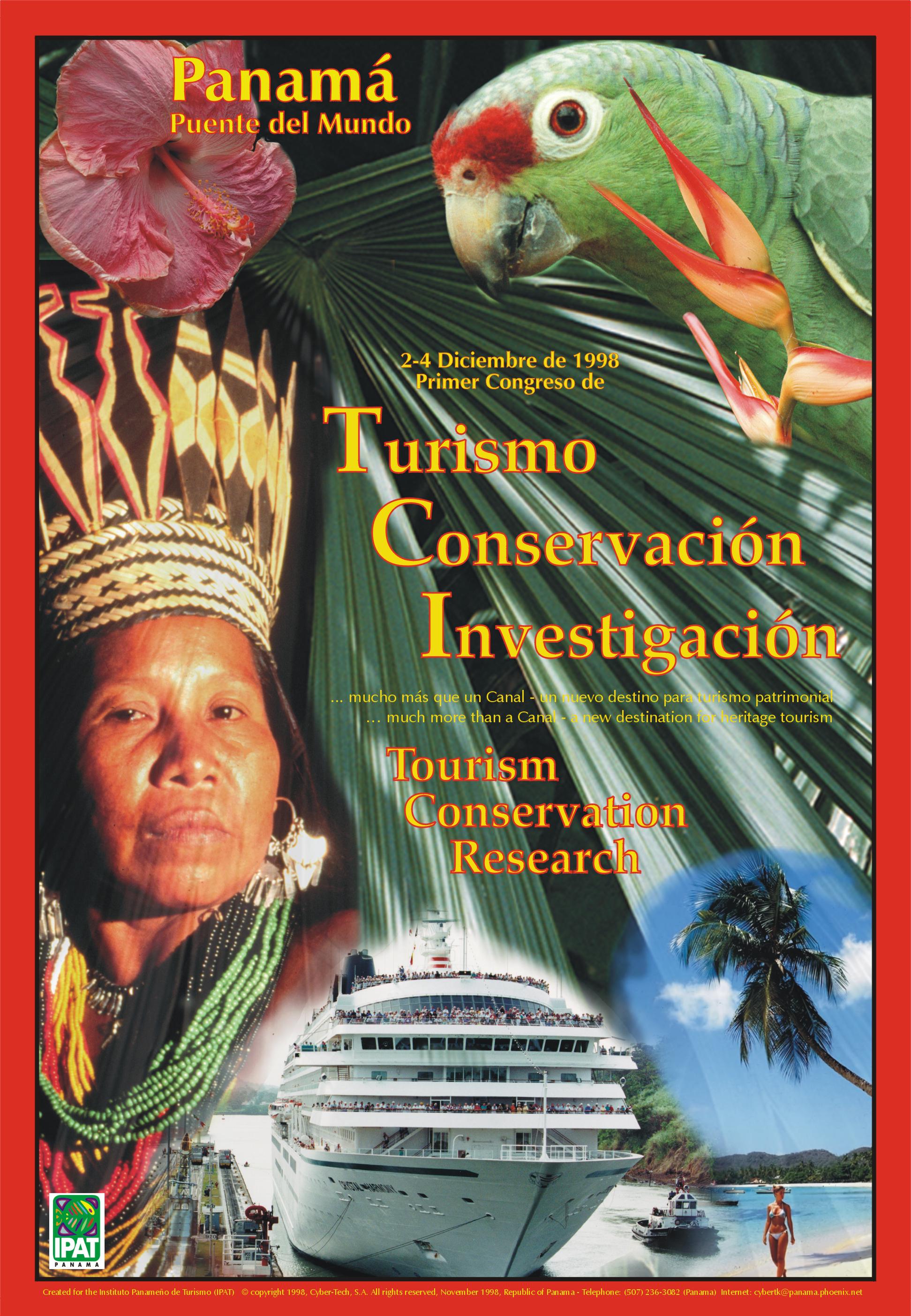
A low resolution image of a 36"x48" poster created for IPAT promoting Tourism, Conservation and Scientific Research. Makes a great 13"x19" color poster for the classroom.

5700 x 3900 pixels - 2 mb
A high resolution image of the Provinces and Indigenous
Comarcas of Panama, 2002
Makes a great 13" x 19" poster
3900 x 5700 pixels - 4.5 mb
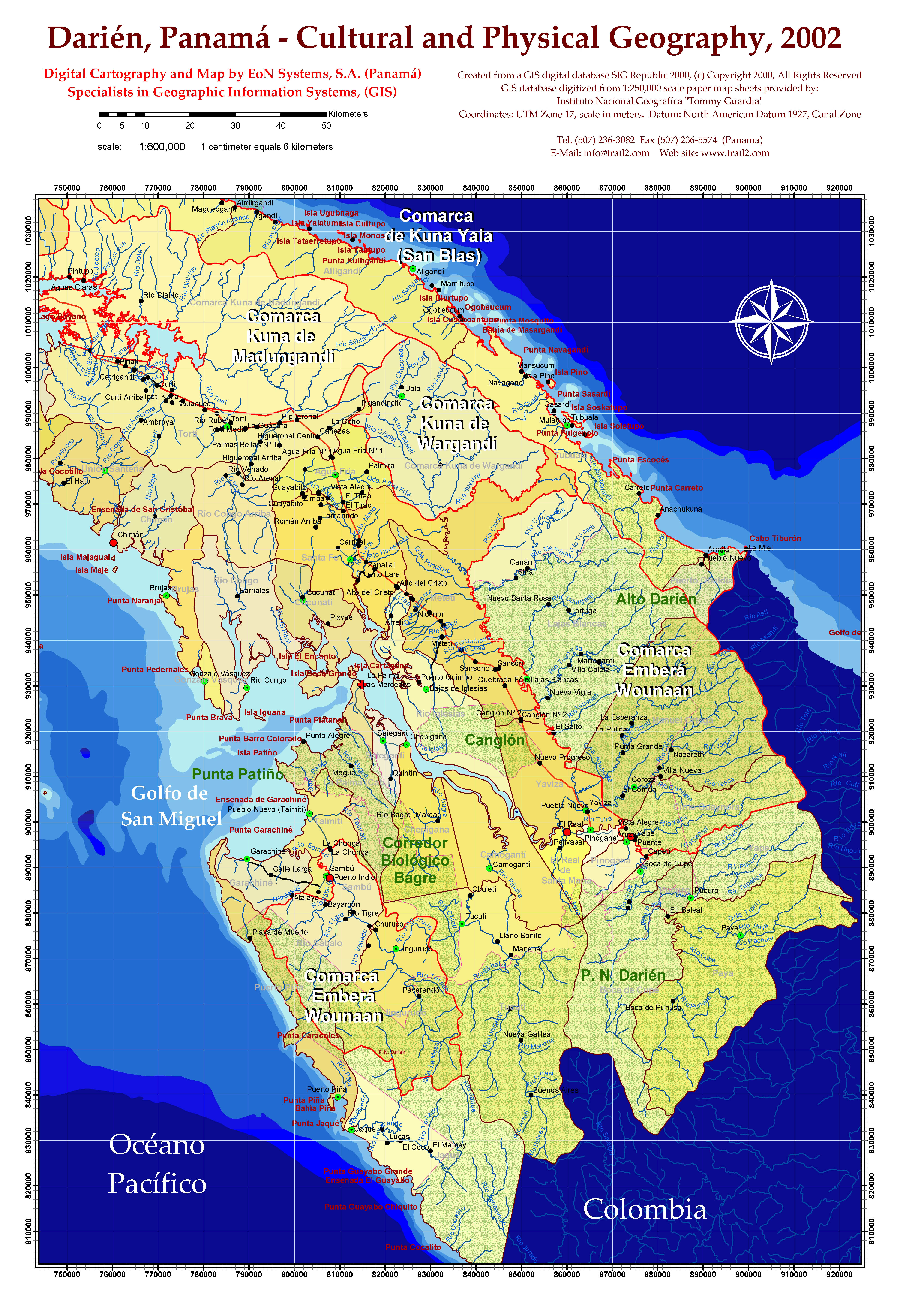
Darién, Panama - Cultural and Physical Geography, 2002 from 1:250,000 scale sources.